


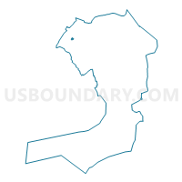
Voting District 3000055, Queens County, New York
About
Outline

Summary
| Unique Area Identifier | 635175 |
| Name | Voting District 3000055 |
| County | Queens County |
| State | New York |
| Area (square miles) | 0.06 |
| Land Area (square miles) | 0.06 |
| Water Area (square miles) | 0.00 |
| % of Land Area | 100.00 |
| % of Water Area | 0.00 |
| Latitude of the Internal Point | 40.75476470 |
| Longtitude of the Internal Point | -73.92100490 |
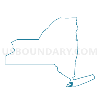
Maps

Graphs
Select a template below for downloading or customizing gragh for Voting District 3000055, Queens County, New York


Neighbors
Neighoring Voting District (by Name) Neighboring Voting District on the Map
- Voting District 3000024, Queens County, NY
- Voting District 3000053, Queens County, NY
- Voting District 3000054, Queens County, NY
- Voting District 3000056, Queens County, NY
- Voting District 3600050, Queens County, NY
- Voting District 3600054, Queens County, NY
- Voting District 3600055, Queens County, NY
Top 10 Neighboring County Subdivision (by Population) Neighboring County Subdivision on the Map
Top 10 Neighboring Place (by Population) Neighboring Place on the Map
Top 10 Neighboring Unified School District (by Population) Neighboring Unified School District on the Map
Top 10 Neighboring State Legislative District Lower Chamber (by Population) Neighboring State Legislative District Lower Chamber on the Map
Top 10 Neighboring State Legislative District Upper Chamber (by Population) Neighboring State Legislative District Upper Chamber on the Map
Top 10 Neighboring 111th Congressional District (by Population) Neighboring 111th Congressional District on the Map
Top 10 Neighboring Census Tract (by Population) Neighboring Census Tract on the Map
- Census Tract 57, Queens County, NY (4,321)
- Census Tract 59, Queens County, NY (4,169)
- Census Tract 159, Queens County, NY (4,136)
- Census Tract 155, Queens County, NY (2,251)
- Census Tract 157, Queens County, NY (1,543)
- Census Tract 55, Queens County, NY (1,067)
- Census Tract 171, Queens County, NY (8)